


John Maunder
The following data sets and comments are from the climate4you.com website developed by Professor Ole Humlum who is a Danish Professor Emeritus of Physical Geography at the University of Oslo, and Adjunct Professor of Physical Geography at the University Centre in Svalbard.
The website climate4you.com which he edits endeavours to provide an ongoing climate data website that is updated monthly.
It uses data of significant national and global sites such as NASA, WMO, NOAA, UEA, NCDC, IPCC, BoM, SIDA, UAH, NIWA. The objective of the website is to provide information on meteorological and climatological issues of general and specific interest.
Recent Global Air Temperature Change, an Overview
All temperature diagrams shown below have 1979 as starting year. This roughly marks the beginning of the recent period of global warming, after termination of the previous period of global cooling from about 1940. In addition, the year 1979 also represents the starting date for the satellite-based global temperature estimates (UAH and RSS).
For the three surface air temperature estimates shown (HadCRUT, NCDC and GISS) the reference period differs. HadCRUT refers to the official “normal” WMO period 1961-1990, while NCDC and GISS as reference instead uses 1901-2000 and 1951-1980, respectively, which results in higher positive temperature anomalies.
For all three surface air temperature records, but especially NCDC and GISS, administrative changes to anomaly values are quite often introduced, even for observations several years back in time.
Some changes may be due to the delayed addition of new station data, while others probably have their origin in a change of technique to calculate average values.
It is clearly impossible to evaluate the validity of such administrative changes for the outside user of these records. In addition, the three surface records represent a blend of sea surface data collected moving ships or by other means, plus data from land stations of partly unknown quality and unknown degree of representativeness for their region.
Many of the land stations have also moved geographically during their existence, and their instrumentation changed.
The satellite temperature records also have their problems, but these are generally of a more technical nature and therefore correctable.
In addition, the temperature sampling by satellites is more regular and complete on a global basis than that represented by the surface records.
It, therefore, is realistic to recognise that the temperature records are not of equal scientific quality. At the same time the big efforts being put into all five temperature databases should be gratefully acknowledged by all interested in climate science.
On this background, the present website has decided to operate with three quality classes (1-3) for global temperature records, with 1 representing the highest quality level:
Quality class 1: The satellite records (UAH and RSS).
Quality class 2: The HadCRUT surface record.
Quality class 3: The NCDC and GISS surface records.
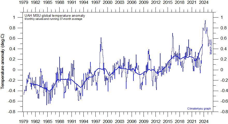
The Satellite Records (UAH and RSS)
Global monthly average lower troposphere temperature since 1979 according to University of Alabama at Huntsville (UAH), USA. This graph uses data obtained by the National Oceanographic and Atmospheric Administration (NOAA) TIROS-N satellite, interpreted by Dr. Roy Spencer and Dr. John Christy, both at Global Hydrology and Climate Center, University of Alabama at Huntsville, USA. The thick line is the simple running 37 month average, nearly corresponding to a running 3 yr average. The cooling and warming periods directly influenced by the 1991 Mt. Pinatubo volcanic eruption and the 1998 El Niño, respectively, are clearly visible. Reference period 1991-2020.
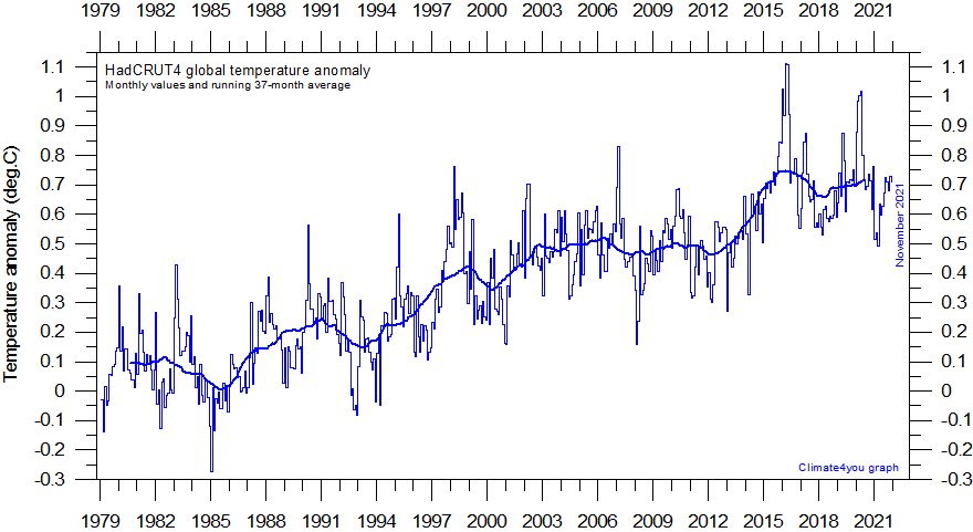
The HadCRUT Surface Record
Global monthly average surface air temperature since 1979 according to Hadley CRUT, a cooperative effort between the Hadley Centre for Climate Prediction and Research and the University of East Anglia’s Climatic Research Unit (CRU), UK. The thin line represents the monthly values, while the thick line is the simple running 37 month average, nearly corresponding to a running 3 year average. An introduction to the dataset has been published by Brohan et al. (2005). Base period: 1961-1990.
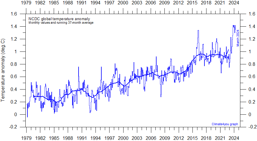
The NCDC and GISS Surface Records
Global monthly average surface air temperature since 1979 according to the National Climatic Data Center (NCDC), USA. This time series is calculated using land surface data from the Global Historical Climatology Network (Version 2) and sea surface temperature (SST) anomalies from the United Kingdom MOHSST data set and the NCEP Optimum Interpolated SSTs (Version 3). The thick line is the simple running 37 month average, nearly corresponding to a running 3 year average. Base period: 1901-2000.
For further Infomation about a wide range of weather/climate matters see my new book Fifteen shades of climate… the fall of the weather dice and the butterfly effect.
BUY Your Own Copy of Dr John Maunders book Fifteen Shades of Climate Today.

Please share so others can discover The BFD.